Deforestation surges - the time is right for Indonesia to protect all of its remaining natural forest.
I. Introduction
In November 2021, during the 26th United Nations Climate Change Conference (COP26) in Glasgow, Scotland, leaders
of 144 nations, including Indonesia, signed the Glasgow Leaders’ Declaration on Forest and Land Use, or the Glasgow Declaration. The declaration
constitutes an agreement to work collectively to halt and reverse forest loss and land degradation.
In Indonesia, efforts to halt deforestation or the loss of natural forests did not begin with the declaration. A
decade earlier, President Susilo Bambang Yudhoyono signed Presidential Instruction No. 10/2011, commonly
referred to as the Moratorium Instruction (Inpres Moratorium), prohibiting the issuance of
conversion permits in primary natural forests and protected peatlands. President Joko Widodo continued this
policy by issuing Presidential Instruction No. 8/2018, or the Oil Palm Moratorium (Inpres Moratorium Sawit), which was intended to
optimize existing oil palm plantations and halt deforestation driven by palm oil expansion.
Indonesia also ratified the Paris Agreement, which aims to keep global temperature increases to below 2°C while
pursuing efforts to limit the rise to 1.5°C above pre-industrial levels. Within this framework, the Government
of Indonesia issued Presidential Regulation No. 98/2021 on the
Implementation of Carbon Pricing and elaborated it in greater detail through Minister of Environment and
Forestry Decree No. 168/2022 on Indonesia’s FOLU Net Sink 2030 for Climate Change Control.
These policies led to falls in deforestation rates in Indonesia for five consecutive years starting in 2017.
However, in 2022, Indonesian deforestation rates began to rise again, as shown in the graph below. Deforestation
in Indonesia subsequently surged in 2025.
Deforestation
in Indonesia,
2001–2025
II. Methodology
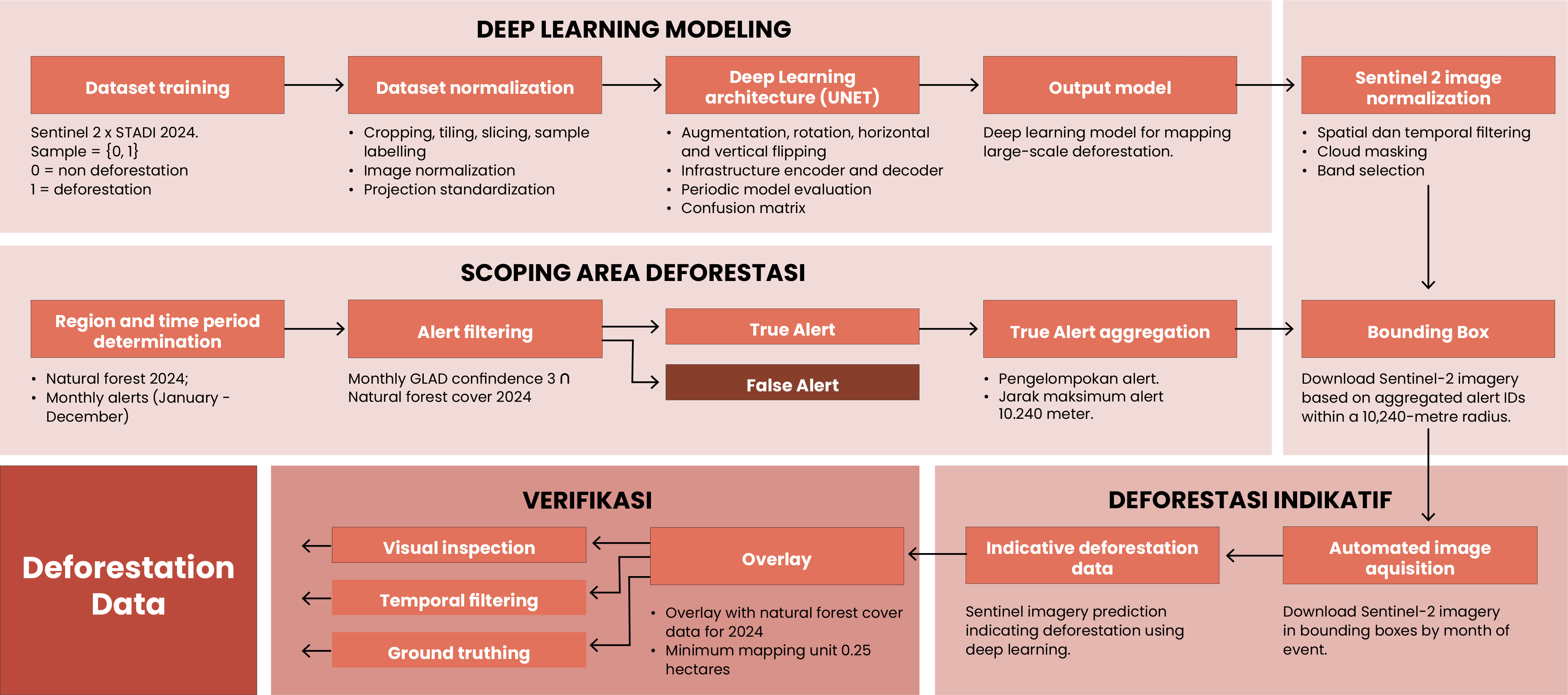
Stages and Data Processing: The 2025 deforestation map was produced using deep learning
modeling on Sentinel satellite imagery. The stages were as follows.
1.
Deforestation modelling. Knowledge accumulated to date – from field monitoring
and deforestation data for 2023 and 2024 – was modelled with U-Net deep learning. This model was
then trained on 10-meter resolution Sentinel satellite imagery.
2.
Defining scoping areas (scoping area). Monthly deforestation alerts
produced by the University of Maryland (usually referred to as GLAD alerts) were compiled. For
efficiency, only high-confidence alerts were collected. These alerts were then “bound” or
aggregated in bounding boxes with search radii of 10,240 meters. These bounding boxes then
became the scoping areas.
3.
The developed deforestation model was then run on 10-meter
resolution Sentinel-2 satellite imagery in the defined scoping areas.
4.
Areas where deforestation was identified (indicative deforestation) were overlaid with forest
cover maps. Four forest cover references were used: (1) MapBiomas Indonesia; (2) land cover maps
produced by the Ministry of Forestry; (3) tropical-moist forest (TMF) data produced by the
European Commission’s Joint Research Centre; and (4) the Forest Persistence dataset produced by
Google.
5.
Verification processes: Indicative deforestation outside the four forest cover
references (forest-reference area) were inspected visually. Due to the large numbers of
polygons and limited time available, polygons smaller than one hectare could not be inspected
and were consequently excluded from the deforestation area. For indicative deforestation inside
forest-reference area, visual inspections and historical screening (temporal filtering) were
conducted on areas larger than 10 hectares, as well as on all areas under 10 hectares located
inside concessions and conservation areas. Areas identified as false positives or not having
deforestation were removed from the dataset, whereas areas that were not inspected (below 10
hectares) were included as deforestation areas.
Verifications were also carried out through field visits and on-the-ground documentation. In
total, Auriga Nusantara conducted field visits covering 49,321 hectares of deforestation sites –
equivalent to 11% of total deforestation in 2025 – across 38 villages in 28 regencies spanning
16 provinces in Sumatra, Kalimantan, Sulawesi, Nusa Tenggara, the Maluku Archipelago, and Papua.
6.
Filtering: Focusing on deforestation caused by human activity (anthropogenic deforestation),
filtering was conducted to exclude deforestation areas resulting from landslides or river
shifts. For example, 11,693 hectares of forest cover were lost due to landslides in Aceh, North
Sumatra, and West Sumatra in the hydrometeorological disaster at the end of 2025. Loss of forest
cover due to river shifts was also relatively prevalent in conservation areas.
Stages and processing of
deforestation data 2025
Accuracy Assessment:. To determine the level of precision of the 2025 deforestation data,
an accuracy assessment was conducted by visually inspecting deforestation polygons using PlanetScope
imagery with a spatial resolution of 3.7 meters. The polygons selected for inspection were chosen
randomly using a stratified random sampling method. Deforestation polygons were grouped by area, namely:
<0.5 ha, 0.5–1 ha, 1–5 ha, 5–10 ha, 10–50 ha, and>50 ha. The number of samples was determined using the
Slovin formula with a 5% margin of error.
Results of this accuracy assessment showed the 2025 deforestation data having an accuracy level of 89%, as
presented in the table below.
Accuracy assessment result of the 2025 deforestation data
Deforestation Area
Accuracy Test
Strata (ha)
Area (ha)
Polygons
Sample
Polygons
TRUE
Accuracy
<0,5
59.743
322.725
261
227
87%
0,5 – 1
58.260
84.211
69
61
88%
1 – 5
149.159
77.445
63
59
94%
5 – 10
44.585
6.495
6
6
100%
10 – 50
69.113
3.648
3
3
100%
> 50
52.892
432
1
1
100%
Total
433.751
494.956
403
357
89%
Swipe the table to the side to view all columns.
III. Deforestation in 2025
With the methodology outlined above, deforestation in Indonesia by 2025 reached 433,751
hectares, an increase of 66% compared to the 261,575 hectares
recorded for the previous year. The
largest area of deforestation once again occurred in Kalimantan, followed by Sumatra. Papua, which ranked
fourth in 2024, rose to third place in 2025, overtaking Sulawesi.
The following table displays the deforestation data per major island in Indonesia for the years 2023-2025.
Deforestation per major island in Indonesia
Sumatera
thousand hectares
Kalimantan
thousand hectares
Sulawesi
thousand hectares
Papua
thousand hectares
2021
229.982
ha
2022
230.760
ha
2023
257.385
ha
2024
261.574
ha
2025
433.751
ha
Swipe the table to the side to view all columns
Island
Deforestations (ha)
Expansion 2025 vs 2024
2023
2024
2025
Hectares
Percent
Kalimantan
124.611
129.896
158.283
28.387
22%
Sumatera
33.311
91.248
144.150
52.901
58%
Papua
55.981
17.341
77.678
60.337
348%
Sulawesi
36.814
17.361
39.685
22.324
129%
Maluku
4.034
3.537
7.527
3.989
113%
Bali & Nusa Tenggara
2.052
1.780
4.209
2.429
136%
Jawa
582
411
2.221
1.810
440%
Total
257.385
261.575
433.751
172.177
66%
Deforestation occurred in all Indonesian provinces except the Jakarta Special Capital Region and the Special
Region of Yogyakarta. Where the top ten provinces for deforestation in 2024, in order, were: (1) East
Kalimantan, (2) West Kalimantan, (3) Central Kalimantan, (4) Riau, (5) South Sumatra, (6) Jambi, (7) Aceh,
(8) North Kalimantan, (9) Bangka Belitung, and (10) North Sumatra, the top ten ranking in 2025 shifted to:
(1) Central Kalimantan, (2) East Kalimantan, (3) Aceh, (4) West Kalimantan, (5) Central Papua, (6) West
Sumatra, (7) North Sumatra, (8) North Kalimantan, (9) Riau, and (10) Highland Papua.
Three provinces that experienced catastrophic landslides and flooding in northern Sumatra at the end of 2025
recorded dramatic increases in deforestation: Aceh (426%), North Sumatra (281%), and West Sumatra
(1,034%).
Deforestation occurred in 383 regencies/municipalities, or 74% of Indonesia’s total of 514, down from 428 in
the previous year. The top ten regencies for deforestation were in Kalimantan and Papua, accounting for
95,733 hectares or 22% of national deforestation.
Seen in terms of land control status, 307,861 hectares (71%) of deforestation occurred inside forest estates
managed by the Ministry of Forestry, while 125,890 hectares occurred in other land use areas (APL) managed
by regional governments or land/concession holders.
Deforestation in conservation areas surged from 7,704 hectares in 2024 to 25,077 hectares in 2025 This
deforestation occurred in 163 conservation areas. The top ten conservation areas alone accounted for 17,153
hectares, or 68% of total deforestation within all conservation areas.
Deforestation of 156,463 hectares – excluding double counting in overlapping habitats – occurred in 29
million hectares of tiger, rhino, elephant and orangutan habitats.
In late December 2024, two months after the inauguration of President Prabowo Subianto and Vice President
Gibran Rakabuming Raka, the Government of Indonesia launched a food security program allocating 20.6 million
hectares of the forest estate for food, energy, and water reserves. A total of 78,213 hectares, or 18% of
national deforestation occurred within these designated areas.
Around 44% of deforestation occurred inside concession areas, with forestry concessions accounting for the
highest percentage (58%). The majority of deforestation in concessions (65%) occurred in Kalimantan.
Deforestation amounting to 41,162 hectares occurred inside 1,140 mining permit or concession areas, with the
top ten accounting for 22% (8,929 hectares).
Deforestation
in Indonesia by month, 2025
Deforestation amounting to 37,910 hectares occurred inside 719 oil palm concessions throughout 2025, with
the top ten concessions accounting for 36% (13,610 hectares).
Deforestation amounting to 110,898 hectares occurred inside 486 forestry concessions, with 74,409 hectares
in logging concessions, 33,063 hectares in pulpwood concessions, 671 hectares in ecosystem restoration
concessions, and 2,754 hectares in other forestry concessions.
Deforestation occurred in 212 pulpwood concessions, with the top ten accounting for 34 percent.
Deforestation occurred in 237 logging concessions, with the top ten accounting for 28 percent.
Deforestation by province Deforestation by district Deforestation in conservation areas Deforestation
in
habitats of iconic megafauna Deforestation within concessions
2025 Deforestation Thematic Map
Select analysis type · 2025
Memuat data peta..
Deforestasi berbasis provinsi
Tabel
Data
”
Of 433,751 hectares of deforestation area, 166,590 hectares are above 5 hectares deforestation spots. 62% of deforestation occurred on spots smaller than 5 hectares, with 149,159 hectares occurring on 1 to 5 hectare spots.”
IV. Discussion
1.
Government policies have contribute to deforestation
During the Joko Widodo presidency, particularly the second term, environmental protection weakened,
especially with the enactment of the Job Creation Law or Omnibus Law. For example, the requirement for
every region to maintain at least 30% forest cover was removed from regulatory text. Further, government
projects, particularly those labeled National Strategic Projects, were afforded flexibility to encroach
on forest estates. Such projects are often not accompanied by adequate planning, including spatial
planning.
The Prabowo–Gibran presidential era appears to be persisting with this policy. Its doggedness in
continuing the food estate program in Merauke is one such example. The government is developing rice
fields in Merauke while, at the same time, eradicating rice fields in Sulawesi for smelter construction
and nickel mining expansion. Not only that, these nickel mines have triggered the destruction of sago
plants in eastern Indonesia, despite sago being a staple food in the region.
At the end of December 2024, two months after the inauguration of Prabowo–Gibran, the government
launched a program to designate 20 million hectares of forest for food, energy, and water reserves. As
things progressed, the total area became 20.6 million hectares. Auriga Nusantara analysis shows 8.8
million hectares of natural forest inside these designated reserves, and 18% of deforestation in 2025
occurring within such areas. This deforestation was driven by populist food programs, such as the
Community Ricefield Development or Cetak Sawah Rakyat (CSR) program in Central Kalimantan – the province
with the highest deforestation area in 2025, despite ranking third in 2024.
The issuing of conversion permits for mining, oil palm plantations, and industrial timber plantations in
areas with natural forest is another major driver of deforestation. Auriga Nusantara’s analysis
indicates that, as of 2024, there were 9.6 million hectares of natural forest cover within conversion
concessions. In 2025, deforestation inside these concessions reached 114,823 hectares, or 26% of
national deforestation.
Additionally, the release of forest estate to become other land use (APL) areas, despite still having
natural forest cover, often marks the initial step towards deforestation, as logging inside APL areas is
not against the law. Such forest estate releases frequently occur to accommodate specific concessions or
at the request of regional governments through spatial planning revisions (RTRW). As of 2024, there were
10.2 million hectares of natural forest inside APL areas, and in 2025, deforestation in such areas
reached 125,997 hectares, or 28% of national deforestation.
2.
The epicenter of deforestation is shifting to Papua
Kalimantan once again recorded the greatest extent of deforestation, making it the region with
Indonesia’s highest deforestation rate for consecutive years since 2013, or for 13 years in a row. However, the greatest increase in
deforestation in 2025 occurred in Papua, with 60,337 hectares positioning the island in third place
behind Kalimantan and Sumatra, overtaking Sulawesi which ranked third for deforestation in 2024.
Government programs, such as National Strategic Projects and food estates, are key drivers of increasing
deforestation in Papua. Infrastructure development, which frequently follows fragmentation to form new
administrative regions, has also contributed to forest loss on the island. Similarly, the expansion of
monoculture commodities, particularly oil palm, has further accelerated deforestation.
This combination of factors must be afforded serious attention in efforts to curb deforestation in Papua
moving forward. Simulations conducted by Auriga Nusantara in Aceh and Riau show that deforestation
surges once palm oil mills begin operating, and the closer an area is to a mill, the higher its
deforestation rate will be. A similar phenomenon has occurred in Sulawesi and North Maluku since nickel
smelters began operating in 2016. Accordingly, infrastructure development and fragmentation of
administrative regions in Papua will make the establishment of new mills or processing industries a
likelihood. Moreover, most oil palm plantations in Papua are still young and are expected to reach peak
production within the next 5–10 years, increasing the need for processing mills. If such mills do
appear, and infrastructure continues to improve, how can deforestation rates on the island be held back?
3.
Expansion of industrial commodities is a key driver of deforestation in
Indonesia
Expansion of industrial commodities remains a major threat to Indonesia’s remaining natural forests. The
development of new oil palm plantations is a primary driver of deforestation in Sumatra, as has happened
in Sijunjung Protection Forest in West Sumatra. Deforestation for oil palm development has even
encroached into conservation areas like Rawa Singkil Wildlife Sanctuary in Aceh.
Deforestation from oil palm expansion has tended to slow, partly due to market saturation. However,
government biodiesel subsidy policies, unaccompanied by safeguard mechanisms for forests, continue to
drive deforestation. After previously mandating a biodiesel blend containing 30% palm oil (B30), which
then increased to B35, since early 2025, the government has been applying its B40 policy.
In Kalimantan, the main driver of deforestation is the expansion of pulpwood plantations for the pulp
and paper industry. The issuing of a license to build the giant PT Phoenix Resources International pulp
mill in Tarakan, North Kalimantan, is the main cause, as the mill lacks its own managed supplier
concessions. Much of the deforestation occurring in Central and East Kalimantan leads to this mill.
The global boom in electric vehicles is a driver of nickel mining and processing industry expansion.
Permits for these industries being issued without clarity over raw material sources, particularly to
avoid deforestation, resulted in a surge in deforestation in Sulawesi and North Maluku.
Nickel mining is nothing new in Sulawesi, and dates back to the 1930s, with nickel smelters being in
operation since 1973. Prior to 2014, only three smelters were operating in Sulawesi, before the number
grew rapidly during the Joko Widodo presidency. From 2014 to 2024, at least 16 new nickel smelters began
operating on the island, which has one of the world’s highest levels of endemism.
Rising gold prices have also contributed to deforestation. Notably, two gold mining concessions – PT
Agincourt Resources and PT Blok Waringin Agung – rank among the top ten deforesters among mining
concessions.
4.
Legal deforestation as a root cause
One effect of Indonesia’s convoluted regulatory framework is difficulty in recognizing whether
deforestation is legal or illegal. While many regulations aim to protect forests, numerous loopholes
render them unprotected.
In a presentation to Commission IV of the Republic of Indonesia House of Representatives (DPR RI) on
July 15, 2025, Auriga Nusantara revealed that, as of 2024, 41.6 million hectares, or 44% of Indonesia’s
natural forest cover, had no legal protection. Under the current situation, causing forest loss is still
possible through legally permissible mechanisms, such as conversion permit issuance or spatial plan
revisions.
Of all deforestation in 2025, the only deforestation that could be directly classified as illegal was
deforestation in conservation areas (20,077 hectares), in protection forests (80,023 hectares), logging
concessions (74,409 hectares), and ecosystem restoration concessions (617 hectares), totaling 180,370
hectares or 42% of national deforestation. In other words, 58% of deforestation in 2025 constituted
legal deforestation.
5.
Significant deforestation in conservation areas
Currently, government conservation efforts tend to focus only on designated conservation areas within
the forest estate. These include natural sanctuaries such as nature reserves and wildlife sanctuaries;
and conservation estates such as national parks and grand forest parks. Indonesia currently has 22.1
million hectares of conservation areas.
However, a large number of ecologically important areas lie outside conservation areas. These include
22.8 million hectares of habitat for iconic species – tigers, rhinos, elephants, and orangutans; and
21.6 million hectares of key biodiversity areas (KBAs) identified by the International Union for
Conservation of Nature (IUCN). These areas combined, without double counting, cover 63.5 million
hectares.
Deforestation within conservation areas surged from 7,704 hectares in 2024 to 25,077 hectares in 2025,
an increase of 225%. Meanwhile, deforestation across all conservation areas reached 186,465 hectares,
accounting for 43% of national deforestation.
V. Recommendations
1.
Issue legislation to ensure the protection of all remaining
natural forests in Indonesia
Legal protection over natural forests should ideally be in the form of a law. However,
enacting laws is not easy and often takes years. Even lower tier legislation like
government regulations can take considerable time to develop, largely due to the
intricacies and complexities involved in the cross-ministerial approvals required in
their formulation. Consequently, a presidential regulation would constitute a tactical
breakthrough that could act as an emergency brake to address this issue. Thus, it is
time for President Prabowo Subianto to issue a presidential regulation on the protection
of all remaining natural forests in Indonesia.
2.
Establish and apply instruments to control spatial plan
revisions
In mid-2023, the public was surprised by a proposed revision to the spatial plan for
East Kalimantan Province, which would enable the release of 612,355 hectares of
forest
estate to become other land use (APL) areas, and downgrade the status of 101,788
hectares of forest estate to make it eligible for mining, despite at least 389,596
hectares (55%) of this area having natural forest
cover. Meanwhile,
several months earlier, the North Kalimantan Provincial Government had proposed a
spatial plan revision that would reclassify 762,000 hectares of forest estate. In
Aceh, regional government maneuvering is expected to threaten the protected status
of
the Leuser Ecosystem Area, a designated biosphere reserve and buffer zone for Mount
Leuser National Park. These examples highlight the urgent need for instruments to
control regional spatial planning revisions, guaranteeing such processes are
transparent
and ensuring impacted parties are involved so that any revisions are only in the
public
interest.
3.
Accelerate the expansion of preservation areas, especially
outside
the
forest estate
As noted above, existing conservation estates are far from sufficient to cover all
conservation areas. At least 31,358 hectares of iconic species’ habitats and key
biodiversity areas are located inside APL areas. The Ministry of Forestry’s weak
conservation performance inside the forest estate necessitates new models for
managing
conservation areas. Conservation Law No. 32/2024 has opened space for this through
its
concept of preservation areas. However, the absence of any implementing regulation
has
meant
such areas have yet to be realized. Therefore, the establishment of an implementing
regulation should be expedited. Nevertheless, it should be underlined that such
preservation
areas should adopt new management models; for example, being managed by and for
regional
governments or local communities, with them being the recipients of any economic
benefits,
and coordination or supervision by the Ministry of Forestry.
4.
Redistribute forest management institutions and personnel so that
all natural forests have rangers to protect them
President Prabowo Subianto has reportedly instructed a doubling of the number of forest
rangers – a step deserving of appreciation. However, as Auriga Nusantara has previously
outlined to Commission IV of the Indonesian House of
Representatives (DPR RI), forest protection personnel have tended to be concentrated on
the island of Java. The same applies to budgeting, with allocations per hectare of
forest estate being significantly higher in Java than elsewhere. Therefore, in addition
to increasing personnel numbers – or redistributing authority and management functions
to regional governments – there is also a need to redistribute personnel so that all
remaining natural forest areas have rangers and associated budgets.
5.
Companies that manage areas with natural forest cover should make
environmental, social, and good governance (ESG commitments)
Nearly half of deforestation in 2025 occurred inside concession areas. Meanwhile there are
more than nine million hectares of natural forest cover remaining within conversion
concessions (mining, oil palm, industrial timber). Corporations managing these areas should
declare environmental, social, and good governance (ESG commitments), including not
perpetrating nor being involved in deforestation.
6.
Provide incentives for regional governments, local communities and
corporations that protect natural forest
Perlindungan hutan semestinya dipandang sebagai investasi, selain karena
Forest protection should be viewed as an investment, not only because forests provide
environmental services for the public, but also because economic activities will be
disrupted if the environment is degraded or does not function in the way it should.
Therefore, the state should provide incentives to those who protect forests, including local
communities, regional governments (provincial, regency, and village), and corporations. In
addition to incentives, economic benefits, such as carbon services, should also be
accessible to those protecting forests. Such incentives and benefits could serve as both a
stimulus for forest protection and a provider of financing for long-term protection efforts
by such parties.●
AUTHOR Timer Manurung, Andhika Younastya, Dedy Sukmara, Yustinus Seno, Wahyu Ananta Nugraha, Dendi Alfitrah
DATA PROCESSING Andhika Younastya, Anggun Detrina Napitupulu, Bagus Sugiarto, Cecilinia Tika Laura, Dedy Sukmara, Jumrio Nakul, M. Alichamdan, M. Dendi Alfitrah, Wahyu Ananta Nugraha, Yustinus Seno
VERIFICATION Achmad Rafly Gymnastiar, Aditya Prima Yudha, Adzra Aqila Muthia, Andhika Younastya, Anggun Detrina Napitupulu, Annisa Meira Nurfauziah, Bagus Sugiarto, Cecilinia Tika Laura, Chairul Soleh, Dedi Septyadi Wibisono, Fadela Yunika Sari, Hafid Azi Darma, Jonathan, Jumrio Nakul, Jundy Zaky Makarim, Luhut Simanjutak, M. Dendi Alfitrah, M. Irfan Nurrahman, M. Irfandi Andriansyah, Muhammad Nabil Astaqafi, Nebo Yok Jonah Marpaung, Reza Fahlevi, Rianti Gina Violeta, Riszki Is Hardianto, Sulih Primara Putra, Supintri Yohar Tri Wahyuni, Valentina Yulia Permatasari, Wahyu Ananta Nugraha, Yanuar Vira Febiyanti, Yudi Nofiandi, Yustinus Seno, Zerin Darma Kusuma
ACCURACY ASSESSMENT Dendi Alfitrah, Wahyu Ananta Nugraha, Yustinus Seno, Anggun Detrina Napitupulu, Bagus Sugiarto, Jumrio Nakul.
CREATIVE DESIGN M. Alichamdan, M. Fachri, Thoriq Fa'iqoh
CITATION:
Status deforestation in Indonesia 2025, accessed on [DD/MM/YYYY] via the link [LINK]. Auriga Nusantara. 2025